Wednesday, March 29, 2006

Noticia Especial (lo siento por el castellano malo)

Note: Click on the photos to view full size.


El volcán villarrica cerca Pucón, Chile

27 Marzo 2006

Hoy, Cheryl Horner la andinista muy guapa y muy famosa ha escalado el volcán villarrica 2,847m. Era su primera ascension alpina de un volcan en actividad.

Cuando la pregunté si tenia miedo de caerse, ella dijo
¨¡No te preocupas para me! Me gusta la altura.¨.
¨¿Pero qué tal los crevasses (grietas del hielo)?¨ yo dije.
¨Me reí a los crevasses¨ ella dijo. ¨No estaba asustado.¨
¨¿Y señora, no hubo gas nocivo a la cima del volcán?¨
¨Si claro, pero el gas al volcán no es tan peligroso que cuando mi esposo se tira un pedo. ¡Si puedo aspirar cerca el, puedo aspirar en cualquiera lugar!¨ digo la reina de las andes....


La señora cheryl una andinista muy guapa.


¨Me sigue amigos, vamos a la cima.¨


Cerca la cima. Mira el gas sobre la montaña.


La señora Cheryl cruza un crevasse grande.


La señora piense ¨hmmmm un muy bonito culo¨


La boca del volcán y gas peligroso.


La señora cheryl y su esposo a la cima del villarrica.


La señora prepara para el descenso.


La señora Cheryl dirige el descenso.

Monday, March 27, 2006

Forest Trekking near Pucon, Chile

Note: Click on photos to view full size.


Lake Tinquilco with the Villarrica Volcano in the background


Arriving at Largo Chico. After we took this shot we turned around and there was Dave Goldman.


Araucaria and Beech forest at Largo Chico


No ducks at The Ducks lake.


The park is named after this lake, Huerquehue. It was the highest lake we visited.


You could be forgiven for thinking this Araucaria is a young Bunya Pine, it has very similar foliage.


Spectacular scenery on day one as we descended towards our camp site at Renahue.


Yet another beautiful lake at Pehuen on day two.


Camping at the thermal pools at Rio Blanco. It was raining but the water was hot and we had the place to ourselves.


We had a frosty start to our fourth and last day which was cloud free with a deep blue sky.


A stand of Araucarias at Largo Toro on the final leg of our journey.

Wow, Chile sure has some beautiful National Parks! We have slipped over the border from Argentina and entered Chile for our fourth time specifically to visit the town of Pucon and the nearby National Park of Huerquehue. Our trek started with a 30km bus ride to the Ranger station at Lago Tinquilco where we paid our camping fees and to our surprise, did not have to pay an entrance fee to the park because it was the Ranger´s birthday and he was celebrating by letting everyone in for free that day. (I cannot imagine that happening in Australia.)

There were spectacular views of Lago Tinquilco and the volcano Villarrica as we chugged uphill towards Largo Chico the next in a series of lakes we visited that day. The forest was a mix of beech trees and pines down lower but as we gained altitude the unusual Aracauria trees started to appear. These trees are the same genus as the Hoop Pine and Bunya Pine back home. In fact, on the border track at Binna Burra there is a Hoop Pine with a sign saying ¨Aracauria Cunninghamii related to a tree found in South America¨. They look more like Bunya Pines than Hoop Pines because of the dome shaped top and the leaves. As we crossed the bridge over the stream that exits Chico, who should we meet once again but our old mate Dave Goldman! It seems like we are having parallel trips through Patagonia and it was great to catch up with him again.

That afternoon it was fantastic walking on soft paths littered with Beech leaves and one gorgeous lake after another. Eventually we reached a pass and dropped into the next valley to the North where there was intact forest as far as we could see and pointy granite peaks that would make great climbs if there was more time. (If only flying to Chile was as cheap as flying to New Zealand I would be back every year.) The first camp site was called Renahue and was a grassy area near the junction of two streams. We were joined by three Germans doing the same trek. We had seen a lot of cow manure on the tracks near the camp site and to everyone´s suprise at about seven o´clock in the evening the local farmers on horseback herded some cattle right through the middle of the camp. The funniest thing was that after the horses passed a pig trotted through. Whether he was being rounded up as well or was helping the dogs we don´t know!

On the second day we crossed Paso Las Mellizas and made a long descent to the thermal pools at Rio Blanco. It was raining when we arrived and we were feeling a bit miserable until we hopped into the hot pools and they were just the ticket after two days of hiking. A few drops of rain on the surface made no difference. We had the whole place to ourselves so even though they were outdoor pools it felt very private. As the afternoon progressed the rain got heavier and we wondered what had happened to our German friends. We found out next morning when they appeared out of the cabins of another establishment across the Rio Blanco. They told us how they had started late from Renahue because they were drying out damp sleeping bags. Unfortunately, that meant that they got caught in the afternoon rain and had a terrible time descending the steep slopes. On top of that all their gear was soaked so they were not able to do the return trip.

We returned to Renahue on our third day via an alternate route across Renahue Pass. That night the weather cleared and we were treated to a display of stars equal to anything we have seen at Girraween. It was also bloody cold that night and next morning there was a heavy frost on the grass and tent.

On our fourth and last day we had bright sunshine and a deep blue sky. A slightly different return route took us past yet another picturesque lake called Largo El Toro before descending to Tinquilco once again. Thanks Chile for another world class walk.

Tuesday, March 21, 2006

Bariloche - Switzerland in the Andes

Note: Click on the photos to view full size.


The clock tower on the plaza at Bariloche. Note the people with St Bernard dogs so tourists can pose for a photo (for a fee).


More Swiss architecture in Bariloche


The view from the top of the chair lift was impressive.

Argentina is full of surprises, first it was a Welsh influence at Gaiman, now we find that Bariloche is a little piece of Switzerland. Swiss architecture, Swiss chocolate, chair lifts, St Bernards, mountains and lakes all added to the illusion that we had landed in Europe. We loved Bariloche but decided against doing another trek there as it was all above the tree line and we have had enough mountain terrain for now.

The Welsh in Argentina


Tucking into Welsh tea and cakes at Gaiman


What country are we in?


Welsh architecture at Gaiman in Argentina

In the 1860s a group of Welsh settlers who were tired of English meddling in Welsh affairs and wanted to preserve Welsh traditions were attracted to Argentina by the promise of land by the Argentinian Government. They arrived at the coast near Puerto Madryn and eventually established settlements in the valley of the nearby Chubut river. Up to about 1910 they continued to arrive. The village of Gaiman is now a tourist attraction with its Tea Houses and Welsh architecture.

We did the tourist thing and visited Gaiman to have tea and gorge ourselves on cakes and pastries. They spoke spanish but held on to these Welsh traditions. It was all a bit strange and seemed so out of place.

Point Tombo

Note: Click on photos to see them full size.


The Magellanic Penguins at Point Tombo welcomed us with open arms


The main penguin activity seemed to be sleeping


Penguins hanging around in the shade looking hilarious


The penguin was not too sure what to make of Cheryl´s penguin speak


¨Should I swim to Brazil today? Nah, the water is too cold I´ll go sleep some more.¨

There is a penguin colony 140km South of Puerto Madryn and Valdes, at the peak of the season the population is over 600,000. Right now there is ¨only¨about 200,000 as most of the chicks have their feathers and taken off to live at sea. They actually migrate North to Brazil, these Magellan penguins do not go to the colder Southern waters.

After our Valdes experience we were a bit dubious about another wildlife tour but this time we were rewarded with a very close encounter with these cute little birds. It was a great experience, if you ever get the opportunity, go there!

Valdes Peninsula

Note: Click on the photos to see them full size


The beach at North Point, tourists are restricted to the dunes behind which means that you are 50-100m from the action.


What the killer whales (orcas) come for, sea lion pups learning to swim in the waves near the beach.


Cheryl trying to convince the armadillo to use some block out...


Distant view of elephant seals.

The Valdes Peninsula is well known for its wildlife and was granted World Heritage status a few years ago. I remember hearing about this place 20 years ago when I was last in South America. More recently it became famous as a result of the David Attenborough TV documentary - The Blue Planet. That program showed killer whales chasing sea lion pups in shallow water right up to the beach. Now thousands of tourists flock to the North Point to witness this incredible scene in February and March when the sea lion pups are learning to swim.

So we joined the throng and took a day tour of the peninsula. North point was the first stop and everyone was hoping to see a killer whale. But alas, luck was not with us that day and there were none to be seen. We would have been happy just to see the sea lions however the National Parks people have banned people from the beaches on the whole peninsula so we were kept to the dunes behind the beach and the closest we could get to them was about 50m away. I understand why they have done this to protect the animals. Unfortunately, it means that you do not get much of a wildlife experience. If you want to see a sea lion don´t bother with Valdes, go to Kangaroo Island in South Australia, there National Parks rangers will take you to the beach to see them pretty close.

The main attraction ended up being an armadillo which was very tourist friendly. They are wierd looking things being very cockroach-like in appearance.

Next stop on our peninsula tour was Caleta Valdes to see the Elephant Seals. Again we had a very distant view of the animals which was pretty ho-hum.

My advice if you are thinking of visiting Valdes is to buy some powerful binoculars and a huge telephoto lens if you want photos.

Tuesday, March 14, 2006

Itinery update 13 March

Enough mountains for a while, we have travelled to Puerto Madryn on the Atlantic coast to visit Val Dez Peninsula. This place is famous for the coastal wildlife including the Orcas that come up onto the beach chasing baby seals. This is not the season for the Orcas, that was before Christmas. Fortunately, there are still elephant seals, sea lions, penguins and land animals to be seen and we are doing an all day tour tomorrow to see what we can. Watch the blog for the results of our wildlife adventure.

Sun 12 Mar, Travelled by bus from El Calafate to Puerto Madryn via Rio Gallegos
Fri 17 Mar, Bus to Bariloche
Mon 20 Mar, Bus to San Martin del los Andes
Thu 23 Mar, Bus to Pucon, Chile
Sat 25 Mar, Bus to Buenos Aires, Argentina
Mon 3 Apr, Fly to Iguasu Falls
Fri 7 Apr, Fly back to Buenos Aires
Thu 13 Apr, Bus to Santiago (overnight)
Mon 17 Apr, LAN Airlines S.A. QF 0322, Depart 11:15pm Santiago to Auckland
Wed 19 Apr, Qantas QF 0116, Depart 6:30am Auckland to Arrive Brisbane 8:05am

Sunday, March 12, 2006

The Moreno Glacier


The face of the Perito Moreno glacier with a tourist boat on the right.


Huge ice towers and yes, it was that blue.


Ice cave taken from the tourist boat.

We took a day trip from El Calafate to see the Perito Moreno glacier. This guy is four kilometres across and the ice cliffs are 50-55m tall. That´s over twice the height of the Kangaroo Point cliffs. It is at the Western end of Lake Argentino where there are a number of fiords. The glacier actually extends across the fiord and forms an ice dam that blocks off the flow of water. Every 4-5 years the water breaks through. The last one was in 2004.

Firz Roy and Cerro Torre

Note: Click on photos to see them full size.

There were a couple more famous Patagonian peaks beckoning us, Fitz Roy and Cerro Torre, so we stopped wasting time updating our blog and took off for a three day hike in Los Glaciers National Park in Argentina. We started from the small tourist town of El Chalten and who should we see there but our old friend from Torres del Paine, Dave Goldman. Dave had just finished the walk and due to bad weather had not seen either peak. He told us that some climbers had been waiting for twenty days for the weather to break.

Undaunted, we set off towards Fitz Roy. But sure enough, when we arrived at the first viewing point we could only make out a ghostly outline in the mist.

Our first night was freezing, literally, judging by the frozen puddles we discovered in the morning. The big suprise was that we were greeted by perfecr weather, blue sky and the huge bulk of Fitz Roy standing there reigning supreme over the surrounding jagged peaks. It is one hell of a big rock!

That afternoon we took the three hour trail across to camp Agostini to see Cerro Torre. Once again, this mountain was covered in cloud when we arrived. We were hoping for a repeat of Fitz Roy´s morning weather.

Next morning I dutifully got up before dawn and made my way to join the small expectant crowd stand on the moraine overlooking the lake in front of Cerro Torre. Unfortunately, that mountain did not cooperate and kept its head in the clouds. Cerro Torre is an impressive fang shaped peak but all we could see was the gum. Oh well, that is Patagonian weather for you...


Fitz Roy looms over the camp site early in the morning


The two of us in front of the big fella


This is all we saw of Cerro Torre. It is the peak in the clouds just right of centre.

Saturday, March 11, 2006

Don´t mention the war


We have entered Argentina twice now and both times we saw one of these signs. Las Malvinas is the spanish name for the Falkland Islands. This sign says ¨The Falkland Islands are Argentinian¨. That sounds pretty unambiguous to me. The poms might have thought that Maggy Thatcher settled the matter but obviously the Argentinians don´t agree.

Wednesday, March 08, 2006

Torres del Paine

Note: Click on the photos to see them full size.

At 1,241m the John Garner pass is not particularly high nor is it overly steep. What makes the pass one of the more hazardous places we have visited this holiday is the battering it receives from gale force Westerly winds blasting off the Southern patagonian icecap just a few kilometres away. Combine the wind with the sudden changes in weather that can bring a snow storm even in the middle of summer and you will begin to understand why it is a place to move through quickly and only visit if well prepared to deal with extreme conditions, a place where you are thankful for modern high-tech materials to keep out the cold.

So it was with some alarm that we made a discovery the night before we took on The Pass.

"My boots are worn out and won´t grip anymore" Cheryl was explaining.

"Look at the soles... Uh that´s new, the soles are coming away from the uppers!"

"What´s the other one like?" I asked.

"Hmmm, the same, both of them have let go on the ball of the foot and the heel!"

Do you know that sick feeling you get when your computer crashes and you have not backed up what you have been working on all day? Well, that's how we were feeling about then. Here we were at a very windy, freezing cold and wet Los Perros campsite on the Grand Circuit of Torres del Paine and our options were few. We could walk back for three days and retrace what we had already covered, patch up the boots and take a punt that they will hold together across the pass or wait a day in the hope of better weather before pushing on.

The Grand Circuit of Torres del Paine National Park is without a doubt one of the world's classic walks. Usually done in ten days / nine nights the circuit is 110-120km in length passing through alpine and forest terrain and visiting the best of patagonia's spectacular mountain, lake and glacier scenery. A shorter trek called the W covers the main features of the park in only five days and is very popular in the summer months but we wanted to experience the more remote Northern sector that can only be reached on the full circuit.

The circuit can be executed in a number of ways depending on where you start and finish. We had chosen to begin with a visit to the huge granite monoliths that give the park its name, the Torres (towers) del Paine. (Some argue that the word Paine comes from the Tehuelche language and means pale blue. Others say it is the name of an early Welsh climber.) The three towers are over 1,000m tall and dominate your first views of the park as you approach from the flat pampas country to the East. I had read about these towers for many years in rock climbing journals and mountaineering books and for me they were just as famous as those other man-made towers in Paris and Pisa. So despite a ridiculously heavy pack with 10 day´s food, I trudged up the valley of the Rio Ascensio with Cheryl and we made camp. Although it was 6pm, there was still plenty of light so we took off up the steep ascent from the camp but without packs it was less than an hour before we crested the lookout ridge and there they were in all their glory.


Our first sight of the Towers from the bus as we approached the Park

Photographs taken through a wide-angle lens do not convey the sheer size of these things. Although I had seen many photos of them in the past, I was still gob-smacked when I saw them in real life. And I now have twice the respect for the few elite rock climbers in the world who have climbed these monsters.


Los Torres del Paine

Next morning the alarm dragged me out of a deep sleep in time for a return to the lookout before sunrise when the towers glow in the orange light of dawn. But that day it was not to be. There was a pitter patter of rain on the tent, I rolled over and went back to sleep.


Cheryl in the forest during the beautiful walk from Lake Dickson to Los Perros campsite

At Los Perros sleep was not so easy to come by, there were decisions to be made. We quickly dropped the option of turning back. Where was the sense of adventure in that? We had to at least attempt the pass before giving up.

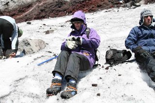
I got down to the business of patching up Cheryl´s boots. We decided to reserve the cloth tape we were carrying for a quick repair in the pass if needed. I had a spare pair of laces for my boots and with one lace per boot and some fancy knot tying I managed to stop the soles of Cheryl´s boots from flapping in the breeze.

In the morning the weather was not promising with gusty wind and overcast sky but at least it was not raining. We waited around until 10am hoping for it to show signs of improvement. It didn´t!

Eventually we decided to just go for it. The first part of the trek to the pass was through forest and there we encountered the worst boggy ground of the whole circuit. We slowly picked our way through the squelsh on bits of wood that had been placed by others. It took us back to the Dusky trek in NZ when our dear friend Barry Cully sunk in mud up to his thighs.

It was getting on towards 2pm by the time we finally cleared the bogs. We looked back and who should we see behind us but Dave Goldman.

Dave is one of those Americans you occasionaly meet who do not fit the stereotype. He is quiet, considerate and an all round nice guy. His most common saying was "I don´t want to crowd your space." We had met on the bus to the park and had stayed at the same camp sites the first four nights so a bond had formed and we had already walked parts of the trail together.

Now that we had company, the track that ascended the open slopes ahead did not seem quite as threatening.

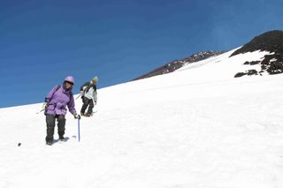
"It´s snowing" said Cheryl as we started off from a chocolate break.


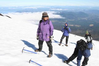
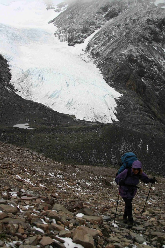
Cheryl makes her way up the John Garner pass with patches of snow on the ground and a glacier far below

A very light snow/sleet was starting and the wind was picking up. Dave was in sight ahead respecting our space. We zipped up our outer layer and pushed on. A little higher we copped our first gusts that knocked us off balance. We looked like we had joined the Monty Python silly walk brigade. As the wind got worse Dave waited for us and we wobbled along together until we could actually see the rock cairn that marked the top of the pass about 500m ahead. Despite the sight of that cairn, our hopes faded as the snow started getting heavier and the wind became so strong that the snow it was pelting at us was stinging our faces and we had to really lean into it to take even a single step. To top it all off, the visibility was quickly reducing to a "white out".

The situation was becoming desperate. Cheryl could not walk at all, it took all her energy to lean on her walking poles and remain upright.


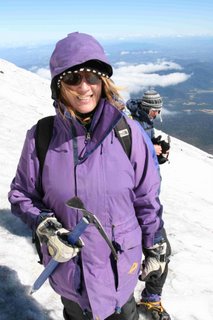
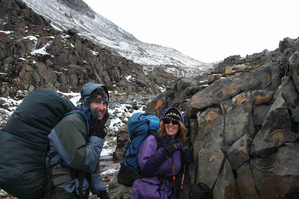
All smiles just before the storm hit. The top of the pass is visible in the background, we could see the rock cairn that marked the top

It was time to retreat, at least to some lower rocks where we could get out of the direct line of the wind. Dave and I started down but Cheryl seemed unable to move. This looked like the first signs of hypothermia setting in, so I badgered her into motion and we started to inch down. It seemed like an eternity but was probably only ten minutes before we reached a rock outcrop out of the wind beside a flat section of track where I reckoned I could pitch my tent if need be. I was ready to do that and get Cheryl into a sleeping bag to warm her up. However, she was fine.

After we put on an extra layer for warmth, Dave noticed that the wind had eased a little and we could again see the cairn in the pass.

We took the opportunity we had been given and started up again. This time, although the wind was very strong, we were not getting peppered with snow and we made it all the way to the pass.

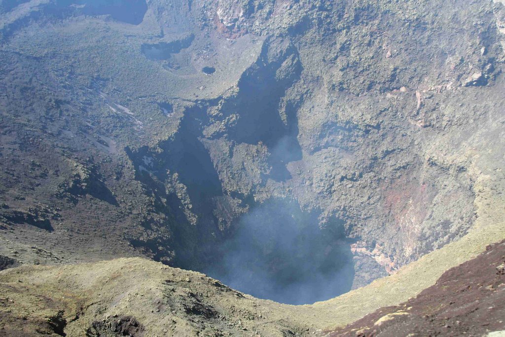
When you are in such a pass, the only thing to do is to get the hell out of it and down the other side. But what a view we beheld on John Garner Pass, the Southern Patagonian Ice Cap and extending from it the panorama of the Grey glacier, 17 kms long and 5-7 km wide sweeping across our field of vision. I was stunned when Cheryl admitted that the misery of the pass had been worth it to see that view.


Dave and Cheryl crossing the pass, the Grey glacier visible below


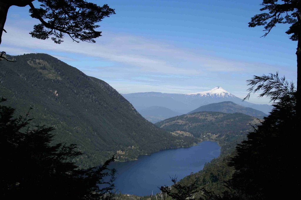
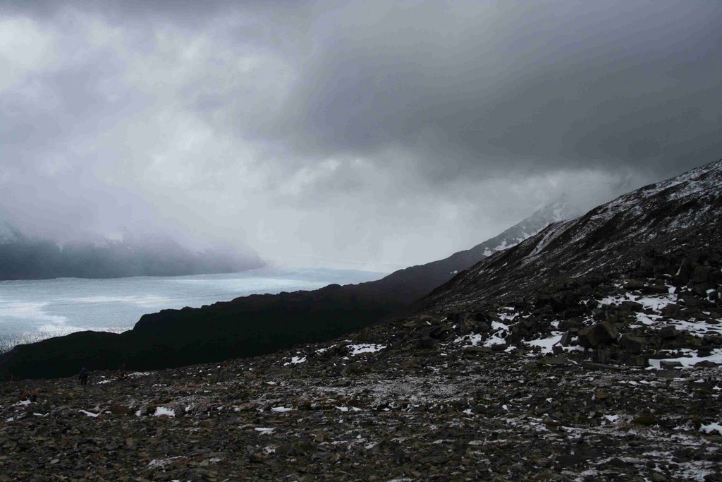
The Southern Patagonian Icecap, Grey glacier and nasty clouds still hanging around after we crossed the pass

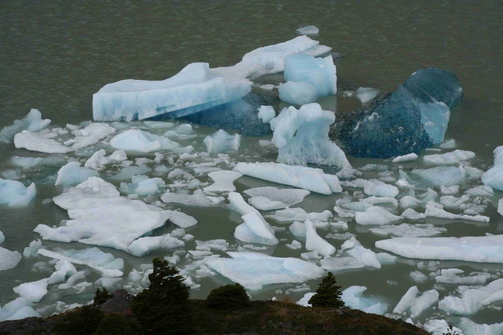
Once through the pass the Grand Circuit follows the sculptured ice of the Grey Glacier to Lake Grey where blue icebergs messmorise trekkers with their beauty. The latter days of the circuit visit the valley Frances and Los Cuernos the "Horns of Paine" unusual peaks of granite capped with shale.


The Grey glacier meets Lage Grey in a wall of blue ice


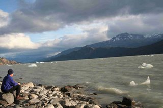
Laurie admiring the icebergs on Lake Grey

Dave went on to complete the full circuit. Cheryl´s boots with the shoe lace repair were still holding together after another four days and 50 kms. We made it as far as Campamento Italiano at the beginning of the Frances Valley where I was struck down with food poisoning from a bad packet of peanuts. I spent a day at that windy, dusty place, in and out of the tent with vomiting and severe diahorria. The following day we retraced our steps the two hours back to Lake Pehoe and took the boat out to the bus.


Cheryl negotiating one of the steeper sections of scree


Icebergs on Lake Grey
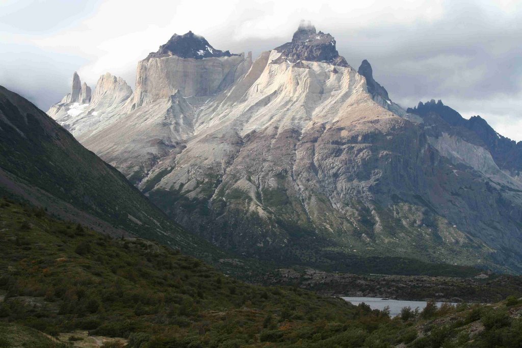
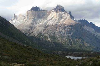

Los Cuernos

So we have a little unfinished business at Torres de Paine. Now, if anyone wants a guide to show them around Patagonia next year Laurie and Cheryl Inc. may be available!


Cheryl´s boots with the shoe lace repair